The Switch Route Model: Modelling bicycle flows based on rider’s behaviour
The Switch Route Model: Modelling bicycle flows based on rider’s behaviour
In 2015, City of Melbourne commissioned SGS to undertake research on rider’s behaviour. The analysis informed their Bicycle Plan 2016-2020. The research provided insight into the impact that the provision of bicycle infrastructure (such as lanes or paths) might have on ridership. The task involved analysing rider’s route choices based on data collected from 24,000 trips by RiderLog between 2010 – 2014.
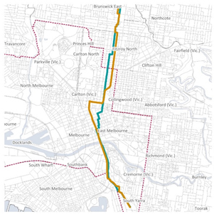
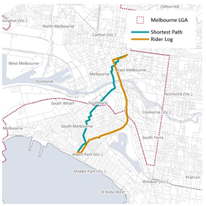
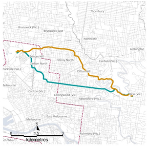
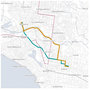
The study showed that most riders take detours from their shortest route, if the option is safer or more comfortable. It showed that 80% of riders in Melbourne would take routes up to 30% longer than their shortest option, if the detour provided a bike lane or path. The figure below shows some examples of the shortest distance vs recorded route.
SGS built a digital network for the inner city area of Melbourne which included bicycle infrastructure and an algorithm that enabled the modelling of preferred routes of cyclists based on the behavioural analysis.
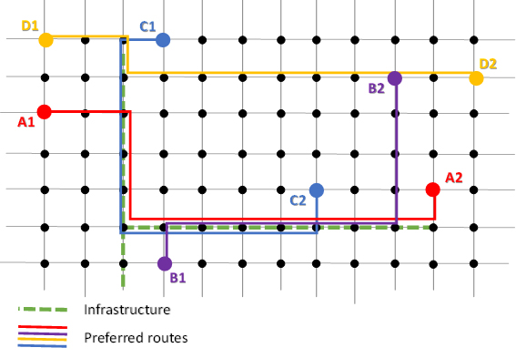
The figure below represents a theoretical example of the preferred route of four riders (A,B,C and D) based on this algorithm. It highlights that riders A and C would extend their route in order to obtain a safer route, while riders B and D would keep the same length but align their route to existing infrastructure.
The Algorithm was used to model Journey to Work data thought the Network identifying the principal bicycle corridors around the City of Melbourne, pinpointing existing gaps in the infrastructure and highlighting the impact that upgrades would have on the network.
The model proved that bicycle infrastructure has a wider impact than just creating a safer path. It also aligns rider flows, grouping riders together on preferred roads which creates opportunities to provide support to the users of these connections. The model showed the importance of corridors such as St Kilda Road, Footscray Road, Royal Parade, Canning Street, Brunswick Street, Swanston Street, La Trobe Street and the Yarra River Path, where the provision of safer connections made them the preferred link for riders.
The model only included Journey to Work trips, which covers close to 60% of the bicycle trips occurring in the City of Melbourne (according to the Victorian integrated Survey of transport activity). The analysis was limited to trips coming into the City of Melbourne from areas up to 12km from the municipality. The data does not display a comprehensive story for locations outside of this area.