What do the actual sub-regions of our cities look like?
What do the actual sub-regions of our cities look like?
Clicking on the interactive map above shows how these self-contained employment markets form across Australia, expanding beyond local and state political boundaries.
In thinking about the urban structure of our metropolitan cities, it is important to acknowledge their natural poly-centricity. Observing and analysing real behaviour patterns reveals ‘natural’ sub-regions within our economy. These sub-regions have differing yet self-contained economies based on their varied employment nodes, strategic assets and demographic profiles.
Being able to delineate ‘natural’ sub-regions enables better decision-making on crucial urban issues: for instance, in knowing where the effects of infrastructure investments will be distributed, or which areas are served by particular activity or employment nodes.
SGS has defined sub-regions in this context using a statistical algorithm which incrementally groups together Statistical Area 2
FIGURE 1
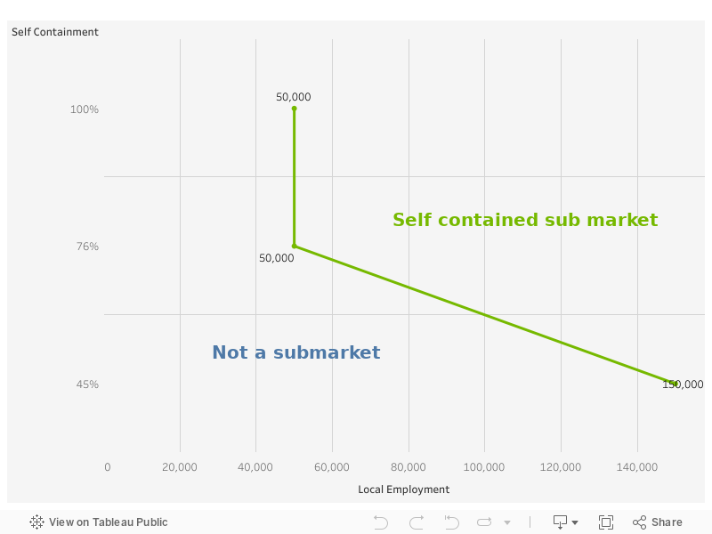
In this process, 2011 ABS Census journey to work data which identifies the both the origin and destination location of workers, is fed into the algorithm. The algorithm finds the smallest and least contained Statistical Area 2 (SA2) and groups it with its most connected SA2. It then repeats this hundreds of times to gradually group up SA2s into sub-regions.
The result is not determined by political boundaries or professional judgement. Rather, each sub-region is a functional economy reflecting where people live and work based on their actual observed behaviour.
The employment nodes within each sub-region play a crucial role in supporting that sub-regional economy and internal hierarchy of centres. Major sub-regional centres, such as Parramatta or Liverpool in particular play a role as the ‘capital(s)’ of their respective sub-regional economy and should be the focus for high order services, employment and transport infrastructure.
Sydney’s ‘natural’ sub-regions
The broader Sydney region hosts almost 1.86 million jobs. More than half of these jobs are located in the ‘Inner’ Sydney self-contained labour catchment, which stretches from Port Botany in the south-east, to Bankstown in the south-west, Hornsby in the north-west and the Northern Beaches to Sydney’s north-east. There are 1.2 jobs for every resident who lives within this Inner catchment of Sydney, with only 12 per cent of Inner residents travelling beyond the catchment for employment. This catchment houses not only the jobs-rich Sydney CBD, but also the employment clusters of North Sydney, St Leonards, Chatswood, and Macquarie Park.
The North West houses 255,000 jobs, many of which are located in Parramatta and the employment cluster at Norwest. Interestingly Parramatta is traditionally associated with Sydney’s west and south-west: however in recent years it has increasingly been pulled into the labour catchment of the north. This shows Parramatta’s increasing integration into Sydney’s Global Economic Corridor that stretches northwards from the Sydney CBD, through North Sydney, St Leonards, Chatswood, Macquarie Park, Norwest and Parramatta. Integrating Parramatta further into this higher-order employment network will have positive flow-on effects for western Sydney, bringing greater employment choice without the need to battle the long distances and congestion associated with accessing the jobs of the Sydney CBD. This regional pull of Parramatta is evidenced by only half the jobs within the North West sub-region being occupied by people of the North West sub-region.
The South West, consisting of Liverpool, Fairfield and the south-west growth corridor stretching down to Camden and Campbelltown, contains 253,700 jobs, most of which (70 per cent) are filled by people within the sub-region. Many of these jobs are within the manufacturing sector.
Sydney’s Outer West sub-region is centred on Blacktown but stretches a great distance northward to Richmond, and west into the Blue Mountains, including Penrith. A majority of this region’s jobs are located within Blacktown, with many (72 per cent) of the jobs filled by people from within the sub-region. This self-contained catchment includes the north-west growth corridor.
The South self-contained labour market largely consists of Sutherland Shire, but also includes the northern extents of Wollongong and land directly south of Sydney Airport.
Finally, and unsurprisingly given geographical constraints, the Outer North, consisting of the Central Coast region, is highly self-contained with 94 per cent of the region's almost 100,000 jobs filled by residents of the catchment.
Footnotes
-
Statistical Area 2: An ABS geographic from the 2011 Census. For instance, there are 275 across Melbourne and they are similar in size to a suburb.